Trekking the Kiwi Land

New Zealand was last part of my "World 2010" trip around the world. I flew in via Melbourne to Auckland on March 2, 2010 from Hobart, Tasmania. This was my first time in the land of Kiwis and Fairy Tales I heard so much about. I spent entire month; 1st week on North and after crossing Cook Strait from Wellington to Pickton 3 weeks on fabled South Island. The landscape is simply stunning; no wonder Lord of the Rings was filmed here! The pace of life is slow, and country still very sparsely populated. There are several National Parks, each beautiful in its own way and worth exploring. Aoraki/Mt. Cook and Fiordland NP in particular left everlasting mark and evoked sense of wonder that makes life so much worth living!

The Kiwi section of Pockets of the World lists treks I did during this time. They are marked by pins on the map; you can follow the links by clicking on the pin. Enjoy your stay, and let me know what you think!

Flying over Tasman Sea from Melbourne
Descending to Auckland

Key Summit (Routeburn Track)

Jagged snow-capped peaks of Fiordland NP from Key Summit

Location:  Fiordland NP, South Island
Distance: ~12 km return trip
Hiking Time: 3 hrs
Start Elevation: 530 m
Max Elevation: 920 
Trailhead: Milford road (Hwy 94) at the Divide, 86 km west from Lake Te-Anau 


Routeburn Track is one of New Zealand great walks. It lies at the base of Southern Alps between Mount Aspiring and Fiordland National Parks and is part of Te Wahipounamu World Heritage Area. It can be hiked either from the trailhead at the Divide on State Hwy 94, or from Glenorchy terminus at north west end of Lake Wakatipu. Access is not as tightly controlled as for nearby Milford Track, but huts are usually full during the season and bookings are required.  Entire distance is about 45 km and most trampers take 3 days for traverse. This track does not receive as much precipitation as nearby Milford or Kepler tracks, but rain gear is a must -- west winds frequently bring huge amounts of moisture from Tasman Sea.


I did not plan on hiking the Routeburn Track. My primary objective was visit to world famous Milford Sound. Except for approach from Tasman Sea, or foot travel, the only access is via 120 km road from Te-Anau. This drive is one fantastic experience, and after Icefields Parkway in Alberta Canada I consider it to be the most scenic road I've ever driven. Some 35 km before Milford Sound the road crests at the Divide -- western terminus of Routeburn Track. I arrived there around noon; I wanted to be at Milford Sound by 4:30 to catch last boat for scenic cruise in the sound. That left me enough time to hike first part of the track to Key Summit and get a feel for this celebrated Kiwi tramp.


Driving up from Te-Anau in mid morning. Clouds are lifting up from Fiordland National Park after couple of days of rain, that also caused temporary closure of Hwy 94 because of landslides. But Kiwi gods eventually smiled at me; the road re-opened and weather was improving. I felt quite excited about finally visiting this fantastic area I wanted to visit for such a long time.


There are many stops along the road worth exploring.  Mirror Lakes are about 50 km from Te-Anau. Guided boardwalk and great photo opportunity on clear day. Very much worth the stop.


Routeburn Track Trailhead at the Divide. The clouds were still low at this point, but I hoped they might lift up by the time I reach the Key Summit. It is only about 5 km and 500 vertical on wide well maintained trail.  I did not have too much time, so I hiked up pretty fast. Along the way I passed several backpackers who were just starting their traverse towards Lake Wakatipu.


First part of the track steadily gains elevation via several switchbacks through some enchanting Fiordland rainforest


After some 45 minutes of hiking and about 300 m of elevation gain, I arrived to the intersection. Main Routeburn Track continues straight towards Lake Howden Hut; the right fork keeps climbing for another 200 vertical meters towards Key Summit Plateau. Most of the track from now on is in the open. The winds picked up, so I had to put on a layer even if I was still climbing.


I waited for some 15 minutes on the summit, but the clouds finally lifted up enough to give me this view of Mt. Hollyford at the west side of Hwy 94. There are some awesome hiking trails there as well; one could spend entire summer exploring this fantastic area. 


I had enough time to hike self-guided boardwalk through wispy goblin moss, before heading down. Needless to say, images from "Lord of the Rings" constantly kept popping in my head.


Entrance to Homer Tunnel

After returning to my vehicle, I proceeded towards Milford Sound. Here, the last act in Fiordland drama unfolded. This part of road wiggles through narrow glacial valleys climbing towards seemingly unpenetrable sheer wall with ribbons of mist and water trickling down like some giant weeping wall -- enterance to Homer Tunnel. This unreal passage was opened only in 1953. About 1.1 km long, and 10% incline -- one way traffic only! Before you had to walk Milford Track to visit Milford Sound -- or come from Western Ocean side.


Bowen Falls in Milford Sound
Milford Sound Sunset

On the other side the road descends to Milford Sound. Some people call it "tourist trap"; I think it is spectacular. I took 2 hour boat ride (about 70 NZD) through the sound -- it was worth every cent. My heart and my soul were overwhelmed. This place is simply too wild to be true -- highly recommended!

Mt Luxmore (Kepler Track) - 1470 m

Fantastic views from 1470 m summit of Mt. Luxmore

Location: Lake Te Anau, Fiordland NP, South Island
Distance: ~24 km return trip
Hiking Time: 9 hrs
Start Elevation: 220 m
Max Elevation: 1470 m
Trailhead: Kepler Track control gate, 4.5 km from Te-Anau townsite


Kepler Track is one of the most celebrated multi-day tramps in New Zealand. About 60 km in length it travels through some of the most spectacular terrain of Fiordland National Park -- true Lord of the Rings territory! The proximity to Te-Anau townsite makes it very attractive proposition. Normally it takes about 3-4 days to hike the entire loop, with camping allowed only in designated areas. Several huts along the way are usually pre-booked during the tramping season -- walk-ins are not recommended. Hiking anti-clockwise is preferred allowing a more gradual climb of 1000 m through cool beech forest to the bushline. It is also necessary to pre-arrange the transportation as Rainbow Beech and Te-Anau (start and end control gates) are some 15 km apart.

I arrived to Lake Te-Anau on Wednesday, March 24 after spectacular drive along great Southern Ocean from Invercargill. I did not plan on hiking Kepler Track; my objective was visit to famous Milford Sound. But when I was checking in to the motel, I was told that 120 km Milford Road (Hwy 94) was closed 2 days ago because of huge landslide. Crews were in the middle of cleanup, and re-opening was expected on Friday; that left me with full day to spare. In park center they recommended to take a boat (about 40 NZD) across the lake to Brod Bay, then hike around the lake back to the townsite. I poked some more on the Internet and saw how this is really just the start of Kepler Track I heard so much about. Day hike of first leg to Luxmore Hut looked like feasible option, and decision was made!

Lake Te-Anau from the townsite the night before. Mt. Luxmore is the snowy peak just left of center. Boat for Brod Bay departs from the jetty at several times in the morning; I decided against taking it as I ddin't want to rush the return -- I figured 5 km extra walk (each way) is not such a big deal. In retrospect that was the right decision.


Next morning I drove to the Te Anau Kepler control gate at south end of the Lake. Huge parking lot, and som interpretive signs testified of the popularity. Here we see the tasteful sign at the trailhead. The weather was overcast, with chances for afternoon clearing. I was really looking forward to the adventure ahead!


First part to Brod Bay was flat and wide -- about 5.3 km. It took me just under an hour of fast pace through some remarkable forest. It was similar to the hike along west shore of upper Kananskis Lake in Alberta, Canada.


Beyond Brod Bay the track passes through nice campsite, then turns away from the lake and elevation gain starts. The track is beautifully graded and well maintained. After about an hour or so I reached Limestone Bluffs at about 740 m of altitude. Here the trail makes horizontal traverse under the cliffs on some exceptionally well constructed foot bridges, then climbs series of ladders to the top of the Bluffs. It is similar to hike up first peak of Stawamus Chief near Squamish in British Columbia.


After Limestone Bluffs, there is still some 45 minutes to the treeline. The forest was simply enchanting -- I was half expecting Frodo to pop-up  and say "Hello"! I should have taken many more pictures here.


I reached treeline some 3 hours into the hike at about 1000 m altitude. Next 45 minutes the track traverses mostly level plateau to Luxmore Hut with some sweeping 360 views. The skies started clearing up promising fabulous afternoon!


Final approach to Luxmore Hut some 3.5 - 4 hours since I left the Trailhead. This is typically overnight spot for people doing entire Track, as well as turning point for dayhikers. Beyond the Hut the track switchbacks up the green slope and enters the bowl under Mt. Luxmore. I stopped for the break, then considered my options. The sign indicated presence of caves worth exploring; but the temptation of bagging a Kiwi summit was simply too strong to ignore!


Wide bowl under Mt. Luxmore with snow starting at about 1200 altitude. The track rises diagonally to the right, then reaches Luxmore saddle at 1400 m -- highest point on Kepler Track. The summit is about 10 minutes of easy scramble from here.


The wind was very strong on the summit, so I spent only few minutes to snap photos. For return I took more direct route straight down the north side aiming to intersect Kepler Track. This idea worked very well and with some minor scrambling I was soon hiking back towards Luxmore hut and enjoying some spectacular afternoon views. Here is the view back to the summit from descent ridge.


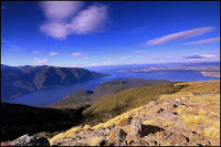
Fabulous views from Lake Te-Anau to far reaches of Fiordland National Park on descent. I've hiked in all continents around the world, but to this day this remains one of most spectacular views I've experienced!


The descent was uneventful I trail ran most of the way and managed to beat the dark and the rain as the skies were closing again. I felt tremendous; I knew I just did one of these special hikes I will remember for a lifetime!  When I drove back to Te-Anau townsite I was treated to this view -- fitting finale to a great day in one of true gems of thie planet. Highly recommended!

Abel Tasman Coast Track

Torrent Bay Viewpoint

Location: Abel Tasman NP,  top of South Island
Distance: ~23 km one way Bark Bay to Marahau
Hiking Time: 8 hrs
Elevation gain/loss: negligable
Trailhead: Marahau south entrance in Tasman Bay


Aoraki / Mt.Cook -- Mueller Hut Track


Mt. Cook and Hooker Valley from Seally Range

Location:  Aoraki/Mt. Cook National Park, South Island
Distance: ~10 km return trip
Hiking Time: 8 hrs
Start Elevation: 750 m
Max Elevation: 1800 m
Trailhead: White Horse Campsite 2 km north from Hermitage Village at the end of Mt. Cook road (Hwy 80)


Mt. Cook is the highest mountain in New Zealand. Also known by its Maori name 'Aoraki' it reaches the height of 3754 m. It lies in the Southern Alps, the mountain range that runs the length of South Island. Along with nearby Mt. Aspiring and Fiordland National Parks it forms one of UNESCO World Heritage Sites.

Mueller Hut is high alpine shelter situated on top of Seally Range and the only one feasible as day destination. The route is steep and scrambly at places, but does not require use of crampons or ice-axes. The views are amongh the best I've ever seen; in my mind this is one of classic hikes that should be on everyone list.


Although not long, the track is quite strenuous. Alternate trailhead is at Hermitage village inside Park Headquarters (end of red line, lower left) but this adds 2 km walk.  Yellow line indicates commonly used start at end of Hooker Valley Road. The Hut itself is tucked in glacial valley behind Sealy range directly above.  No-nonsense ascent gains almost a vertical kilometer in less than 3 km.  There is no trail beyond ridge crest, but the route is flagged with orange markers and requires a couple of class 2 scramble moves before reaching the hut at far end of rocky basin under Mt. Ollivier.

 Driving towards Park Headquarters along Mt. Cook road around 9 am. I stayed for several days at nice motel in Lake Tekapo, about 1 1/2 hours drive. This photo was taken with one hand on the wheel -- by this time driving on left side of the road started to feel more natural from the right! High clouds caused some worries; Aoraki never completely cleared but overall I had excellent conditions throughout the hike.


Mt. Sefton and Footstool dominate the horizon during initial 30 min walk in valley bottom that leads to the start of Sealy Range and beginning of elevation gain. The trail turns sharply left here and begins relentless switchbacking ascent.


The trail is mostly vertical staircase, with wooden steps along the way built by National Park crew to help control the erosion. It is quite similar to infamous Grouse Grind in Vancouver North Shore, except that views are infinitely better.  Views back to the Hooker valley are to the left. Park Headquarters (well worth visiting) are just right of center.


First objective is to reach Sealy Tarns -- small bodies of water about 2/3 of the way up, with great reflections of glaciated Footstool in the distance.  Elevation gain to this point is about 700 m. More than half of people turn around here. The crest of Sealy range is another 300 vertical meters above. Photo taken on return.


Looking down to Hooker Valley from Sealy Tarns. Mueller Lake in lower center.  Long ridge leading from Aoraki to the left towards Bali Pass is popular guided trip.  The term "Long White Cloud" was never more evident than it was here!


Top of Sealy Range, about 40 minutes of scramble up steep-ish scree slopes above the Tarns. The trail ends here, but orange markers indicate the way around the cliffs to the right. It was extremely windy here -- I needed a break, but could not find proper shelter so after a quick bite I continued.  Elevation gain was behind me at this point, and the hut was about 30 minutes away.


Mt. Sefton - on the left photo with amazing Huddleston and Frind ice-flows. Rocky basin leading to the hut on the right. Mt. Ollivier rises behind the hut and is an easy 45 minutes scramble.


Reaching Mueller Hut about 4 hrs of moderate pace from the trailhead. Open year-round,  it is very well maintained with on-site custodian. Outhouse, water-tank, kitchen and lots of bunks. I was surprised to hear that NZ parks rely on your 'good will' to pay for the stay upon the return in park headquarters! Entrance to NZ national parks are free as well; I wonder how long it will stay that way.


After 30 minutes break on the Hut terrace I headed back. I thought about scrambling Mt. Ollivier, but it was clouding over and cold winds made me change my mind. I stopped for this great shot of Mt. Sefton -- New Zealand third highest mountain.


Just before I started descent down Sealy range, one last treat waited -- couple of very exotic looking keas! They were not afraid of me at all, and let me come close I could almost touch them. Thanks for posing!


 The long white cloud that obscured Aoraki for most of the day finally lifted in late afternoon just when I was descending by Sealy Tarns.  Mixed ice/rock climb, the first recorded ascent was only in 1894 by group of Kiwis via Hooker valley and the North ridge.


One last shot of Aoraki during the drive back to Lake Tekapo.  I wish I could have stayed couple of weeks to explore and hike more trails, but it was time to head back and continue Kiwi experience towards great Southern ocean and adventures ahead.